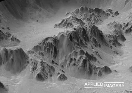
Applied Imagery Quick Terrain Modeller 8.x |379.0 mbThe Applied Imagery Team announced a major new release of its flagship product, Quick Terrain Modeller, the world's premier 3D point cloud and terrain visualization software package.
Quick Terrain Modeler designed for use with LiDAR, but flexible enough to accommodate other 3D data sources, Quick Terrain Modeler provides an easy to use software experience that allows users to work with significantly more data, render larger models, analyze data faster, and export a variety of products.
These benefits enable very powerful, yet simple and intuitive, terrain exploitation.
With each successive release, Applied Imagery makes using Quick Terrain Modeler easier and faster.
Latest release, 8.
0.
4, includes many new tools QTM users have been requesting.
These tools will enable the exploitation of bigger data sets, accelerate frequently used tasks, and make users' lives easier.
What's new:About The Applied Imagery TeamApplied Imagery was founded in 2004 in Silver Spring, MD, a suburb of Washington, D.
C.
, to commercialize software developed at Johns Hopkins University's Applied Physics Lab (APL).
Our commercial, off-the-shelf (COTS) software, the Quick Terrain Modeler, is the world's premier 3D point cloud and terrain visualization software package.
Quick Terrain Modeler is focused on DoD and civilian applications and continues to evolve based on customer feedback.
Product:Applied Imagery Quick Terrain ModellerVersion:8.0.7.2 (build 82335) USA EditionSupported Architectures:x64Language:englishSystem Requirements:PCSupported Operating Systems:Windows 7even or newerSize:379.0 mbNote:It's the USA Version which got no restrictions compared the International Version (because of security laws)
发布日期: 2020-02-25